Hard-coded id of currently selected item: . JSON version of its record is available from Blacklight on e.g. ??
Metadata associated with selected item should appear here...
EAP1274/3/8
- Record Id:
- 040-004316705
- Hierarchy Root Ancestor Record Id:
- 032-004315819
- MDARK:
- ark:/81055/vdc_100159687540.0x000001
- LARK:
- SLARK:
- Format:
- ISAD(G)
- Reference (shelfmark):
- EAP1274/3/8
- Title:
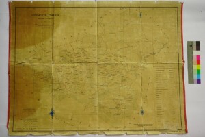
- Gudalur Taluk Map
- Scope & Content:
-
Gudalur Taluk, Nilgiri District Map. Scale 1 Inch = 1 Mile.
Extent: This file containing 1 Map.
Condition of original material: Map is decolored into yellow. Bottom and top portion edges is torn. There are two stains in the left side of the map.
Related regions: Tamil Nadu.
Related towns/cities: Gudalur.
- Collection Area:
- Endangered Archives Programme
- Project / Collection:
- Digital Documentary Resources in Nilgiri and Coimbatore
- Hierarchy Record Ids:
- 032-004315819
040-004316705 - Is part of:
- EAP1274/3 : Collections of Nilgiri Documentation Centre (NDC)
EAP1274/3/8 : Gudalur Taluk Map - Hierarchy:
- 032-004315819[0008]/040-004316705
- Container:
- View / search within Archive / Collection: EAP1274/3
- Record Type (Level):
- File
- Extent:
- 1 TIFF images
- Digitised Content:
- https://eap.bl.uk/archive-file/EAP1274-3-8 (opens in a new tab)
- Thumbnail:
-
- Languages:
- English
- Scripts:
- Latin
- Start Date:
- 1919
- End Date:
- 1919
- Date Range:
- 1919
- Era:
- CE
- Place of Origin:
- India
- Access:
- User Conditions:
- Access is for research purposes only. CC BY-NC.
This item is part of the Endangered Archives Programme.
These collections are not available to request in British Library Reading Rooms.
Digital copies can be viewed online by clicking the thumbnail image or digitised content link.
If you would like further help, contact our Reference Services team, quoting the Reference (shelfmark) above.
- Information About Originals:
- The original material is located in Nilgiri Documentation Centre (NDC), Konnerimukku, Kotagiri, The Nilgiris
- Material Type:
- Maps and Plans
- Legal Status:
- Not Public Record(s)